Researchers at Singapore-MIT Alliance for Research and Technology (SMART), MIT's research enterprise in Singapore, and Nanyang Technological University, Singapore (NTU Singapore), have developed a method that can accurately measure the amount of carbon stored in bogs.
The new method by the SMART-NTU team uses satellite data. By doing so, they aim to reduce the need for on-site sampling to derive the three-dimensional shapes of raised peatlands (also known as bogs) and, hence, the amount of carbon they contain. The new mathematical model replaces earlier models and was developed with collaborators from the Massachusetts Institute of Technology, the University of Potsdam, Stanford University, and the University of Minnesota.
"Measuring carbon stocks in raised peatlands is challenging. The variable shape of bogs and varying depths of their carbon-rich soil known as peat, combined with their inaccessibility and vast size in many tropical regions, makes obtaining accurate data difficult," said the team of researchers.
"Measuring the amount of carbon stored in peatlands helps governments and policymakers assess the environmental impact of converting these lands for agricultural, industrial or urban uses, particularly by understanding potential carbon emissions resulting from peatland drainage," they continue.
Credit: Singapore-MIT Alliance for Research and Technology (SMART)
Globally, the drainage of peatlands for agricultural use releases large amounts of carbon dioxide and increases the risk of catastrophic fires. Dry peat is highly flammable and can easily catch fire, especially in regions with hot climates and dry seasons, such as Southeast Asia - where haze is a recurrent pollution issue. Southeast Asia is home to about 23 million hectares of peatlands, about half of the world's tropical peatlands [1].
The team adds: "Although bogs represent only three percent of the world's land surface, they store the most carbon per area of any land ecosystem on Earth [2]. Understanding bogs is crucial to protect and restore their large carbon stocks. Restoring bogs through a method known as rewetting is one of the most promising nature-based solutions[3] to fight climate change."
First author Dr Alex Cobb, Senior Principal Research Scientist, Singapore-MIT Alliance for Research and Technology, said: "Peatlands have acted as huge stores of carbon since before the time of the dinosaurs. Modern coal deposits started as peatlands. Our mathematical model makes it possible to describe and compare the shape of bogs anywhere, including areas in remote parts of the Amazon Basin, New Guinea, and the Congo Basin that are under threat by development but are still poorly known scientifically. Our finding also has practical applications: the three-dimensional shape of a bog determines the carbon it holds and how it can best be restored. By protecting and restoring peatlands, we can stop the vast greenhouse gas and smoke emissions from drained peatlands, making global climate goals achievable."
Second author Dr. René Dommain, Senior Research Fellow at NTU's Earth Observatory of Singapore, said: "We can now accurately measure the amount of carbon stored in peatlands that could potentially be released due to environmental change caused by human activities, helping countries with large peatland areas in both reporting and protecting their carbon stocks. We can also determine peatland areas at risk of fire due to changes to their morphology from artificial drainage and contribute towards alleviating the recurring threats of haze that plague Singapore and the region. This work is also a foundation for successful restoration of damaged peatlands." Dr Dommain was also a researcher at NTU's The Asian School of the Environment when he co-led the study.
The findings from the study [4] titled "A unified explanation for the morphology of raised peatlands" were published in the top peer-reviewed scientific journal Nature on January 4th.
This research involved analysis using measurements of the earth's surface by airplane-mounted lasers at eight sites around the world, including bogs from Quebec (Canada), Alaska, Minnesota and Maine (USA), Finland, Estonia, Brunei Darussalam, and New Zealand – building on the theoretical findings from a paper [5] published by SMART in 2017 on the ecological and hydrological processes that control the buildup of carbon in tropical peatlands.
The study was carried out by SMART and supported by the National Research Foundation (NRF) Singapore under its Campus for Research Excellence And Technological Enterprise (CREATE) program.
Scaling up measurements in peatlands
The research team claims that scientists can now apply their new method to any bog in the world, which allows them to measure the amount of carbon contained in a bog and mark out areas that could be restored if a bog is already damaged. They checked the validity of deriving the shape of bogs from their model with independently derived Light Detection and Ranging (LIDAR) technology (see Figure 1). In addition, with this new method, the researchers can also determine which parts of the bogs are wet and intact or dry and damaged, pointing to where restoration efforts should be focused.
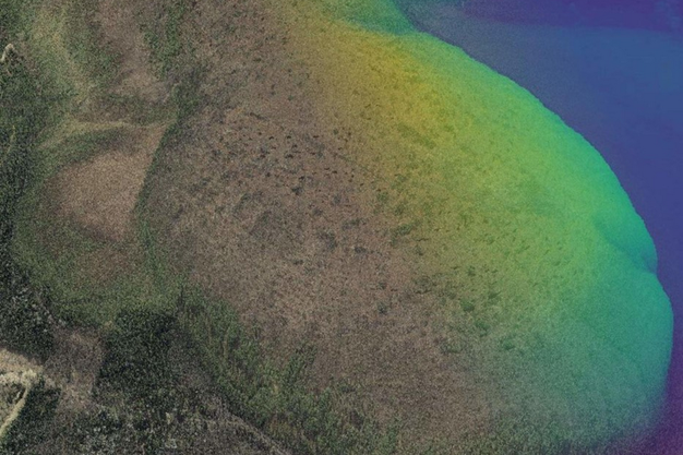
Figure 1: The mounded shape of a raised bog (Valgeraba, Estonia) is revealed by a colored relief map overlaid on aerial photography based on lidar data from the Estonian Land Board. Elevations are exaggerated to emphasize its mounded shape.
"Restoring peatlands by rewetting reduces greenhouse gas emissions and the occurrence of fires. Peatland becomes wet again by blocking drainage channels, like ditches created for agricultural use, and preventing water from draining away. This helps keep carbon stored in the peat, preventing its release into the atmosphere. Rewetting is crucial for reducing greenhouse gas emissions and maintaining the health of peatland ecosystems. Restoring bogs is also beneficial for biodiversity, as by restoring the natural waterlogged conditions, various plant and animal species adapted to wet environments could thrive," the team elaborates.
They add: "Last year, SMART researchers published a paper [6] demonstrating the measurement of the surface of peatlands by lasers on satellites and the International Space Station. By combining these measurements with the model from this study, researchers can describe bogs' shapes and carbon stocks worldwide using simple elevation measurements. Satellites can perform these measurements without the need for labor-intensive ground-based sampling. This finding expands the understanding of global peatlands and provides a foundation for planning natural climate solutions through global restoration or protection of damaged bogs. It also opens up new opportunities for research and commercial applications linked to compliance and voluntary carbon trading markets."
Dr Cob says: "Drainage of peatlands by people now causes the emission of over a thousand of millions of tonnes of CO2 each year and enables catastrophic fires that have caused hundreds of thousands of premature deaths. Rewetting peatlands could stop these emissions and fires, but it cannot be planned effectively without knowing the subtle gradients in peatland shape that drive the flow of water. By estimating the shape of raised peatlands from limited data, our theory makes it possible to plan peatland rewetting more easily and cost-efficiently than has ever been possible."
Dr Dommain states: "We developed the first comprehensive theory that explains the morphology of raised bogs globally, essentially solving the problem that peatland scientists struggled with for over 120 years. Ours is a highly relevant contribution because peatlands are dense stores of pure carbon and play a vital role in climate change mitigation strategies."
The global team of researchers currently makes efforts to expand their analyses to remote peatland regions of the tropics for which few data are available. They plan to develop tools to estimate carbon stocks with this new method to support governmental agencies and the private sector in reducing greenhouse gas emissions from degraded peatlands.
[1] Peatlands in Southeast Asia, Meteorological Service Singapore (2023).
[2] Peatlands store twice as much carbon as all the world's forests, United Nations Environment Programme (2019).
[3] Peatlands and climate change, International Union for Conservation of Nature (2017).
[4] A unified explanation for the morphology of raised peatlands, Nature (2024).
[5] How temporal patterns in rainfall determine the geomorphology and carbon fluxes of tropical peatlands, PNAS (2017).
[6] Improved terrain estimation from spaceborne lidar in tropical peatlands using spatial filtering, Science of Remote Sensing (2023)
For more information:
Nanyang Technological University of Singapore
www.ntu.edu.sg
 Singapore-MIT Alliance for Research and Technology (SMART)
www.smart.mit.edu