Hurricane Dorian strengthened into a Category 5 system and blasted the Bahamas Monday as it approached Florida. Winds in excess of 165 mph cut power, overturned cars, and downed trees, with reports of severe damage to many of the buildings on the island of Grand Bahama.
The next land mass in Dorian's sights is the United States. Before the weekend, the forecast was for Dorian to cross the Florida coast on Labor Day, but the storm has subsequently slowed and now appears to be taking a path brushing the coast from around Palm Beach, Florida, up to North Carolina. It has also slightly weakened to a Category 4 hurricane, but is still considered extremely dangerous.
Wind and rain for Florida
Although the Hurricane may not cross the coast, there is expected to be significant wind along with heavy rainfall for coastal areas. General estimates suggest 10 inches of rain and more are possible for some parts over the coming days. As a result, local authorities have issued evacuations for many coastal areas in Florida, Georgia and South Carolina. Additionally, Port Canaveral, Fort Lauderdale/Hollywood International Airport, as well as Orlando International Airport are all now closed. Miami International Airport, where the majority of the flowers enter the country, will remain open as it is no longer in the Hurricane's path.
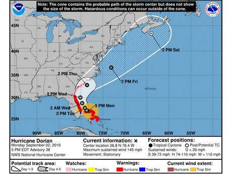 Hurricane Dorian's projected path as at Sept 2 5pm ET. A larger version can be viewed here. Image: National Hurricane Center.